Euro Blocks II
Euro Blocks II, ca.1914, 2013
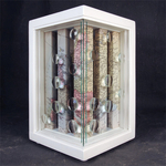
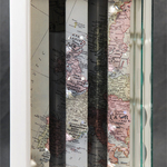
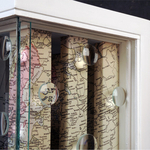
The Geopolitical map of Europe has been dissected and reshaped many times throughout history.
Euro Blocks II, is my second work exploring the changing political alliances.

Construction Information
(7 x 7 x 11")
Interior:
Scanned 1914 Lithograph Map
Balsa Wood Frame and Columns
16 Magnification Lenses
2 - 6.6 x 9.5" Glass Panes
Exterior:
3/4" Maple Painted and Varnished.
Glass Cover
The Geopolitical map of Europe has been dissected and reshaped many times throughout history.
Euro Blocks II, is my second work exploring the changing political alliances.
Construction Information
(7 x 7 x 11")
Interior:
Scanned 1914 Lithograph Map
Balsa Wood Frame and Columns
16 Magnification Lenses
2 - 6.6 x 9.5" Glass Panes
Exterior:
3/4" Maple Painted and Varnished.
Glass Cover
Return to: Gallery
|
|
|

|
Return to: Gallery